|
Please note that the above map and following commentary were placed here for discussion and for information. They are only one person's vision -- mine, Michael Potts's -- of the possibilities and considerations. You may disagree, but please don't attack me for sharing my thoughts. If you have better ideas, or even different ones, please prepare them so they can be displayed here for anyone to see.
7 June 1998
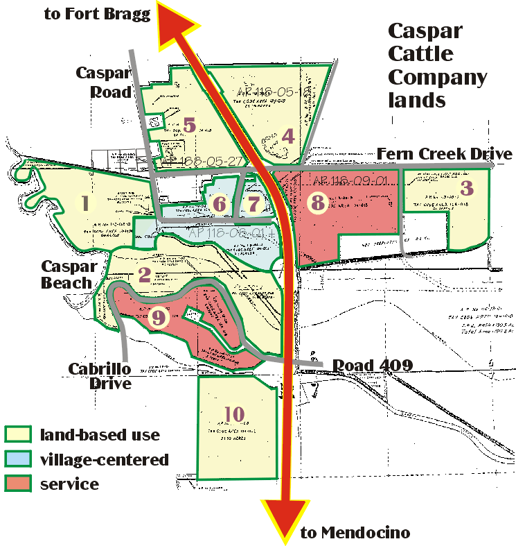
With the breakdown in negotiations between the Coastal Conservancy and the owner of the Caspar Cattle Company (CCC) lands, two new parcels, number (9) and (10) on this map, now enter into the plan. The numbering of the parcels roughly follows the importance attributed by those members of the Caspar Community who have expressed an opinion.
First in importance is preservation of the headlands (1), and next comes the beach and riparian corridor (2). Many residents consider the water source in parcel (3) to be of great importance, and many also agree that the pond and seasonal flyway on parcel (4) is important as well. Parcel (5) has also been identified as important open space or agriculture, and the second growth forest in parcel (10) representing a rare piece of forest west of Highway 1. These 6 parcels are important and valuable principally for the land and what lies under and on it, and any plan must preserve these resources. It is probably that some use is consistent with resource preservation on parcels (3), (4), (5), and (10) but the consensus to date is that parcels (1) and (2) should be preserved and restored to their natural state.
Parcels (6) and (7) are the residential center of the village. Access to them is through village roads, and so non-residential development is difficult to imagine.
Parcel (8) lies mostly below the viewshed west from Fern Creek road, and out of sight from Highway 1, and so is the only parcel north of Caspar Creek which could be developed without much visual impact. There would certainly be more traffic at the intersection of Fern Creek and Highway 1. The point of land south of Caspar Creek (parcel (9)) has some climax trees which serve as osprey nesting sites, and surrounds the historic Caspar Cemetery, but it is possible that careful commercial development on this parcel could enhance Caspar village without impacting traffic.
|